News and Achievements

گزارش پنج ساله پژوهشکده محیط زیست دانشگاه تبریز 1395-1400
Morphology, ecology, taxonomy and biogeography of Stauroneis pachycephala P.T. Cleve (Bacillariophyta) and its transfer to the genus Envekadea Download
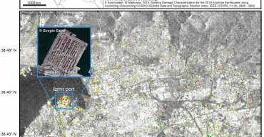
After the M7 earthquake near Samos island, InSAR change map of Izmir is produced from a set of Sentinel-1 images (24 days) over the built-up areas. Forward changes can be interpreted as possible earthquake damage if other anthropogenic activities (reverse changes) do not exist. In the disaster-stricken area some anthropogenic activities can be detected if […]


On the 4th August 2020 two severe explosions occurred in Beirut. We have used three synthetic aperture radar (SAR) images with VV polarization to apply InSAR coherence detection method to identify the damaged/collapsed buildings.

Synthetic aperture radar (SAR) damage map for Beirut (Lebanon) explosion is created from co-polarization descending Sentinel-1 data (VV) between 2020.07.24 and 2020.08.05. The affected areas are detected from a relative change of backscattering coefficient and RGB color composition. The urban areas are extracted from the global urban footprint (GUF). Red areas are possibly damaged areas, […]

Preliminary flood mapping in Kyushu island using ascending-descedning ALOS-2 PALSAR-2 images

On July 4, 2020, heavy rain hit Kyushu island, Japan and left considerable damage and victims. Synthetic aperture radar (SAR) flood map for southern Japan is created from co-polarization descending Sentinel-1 data (VV) between 2020.06.22 and 2020.07.04. The flooded areas are detected from relative change of backscattering coefficient. Jenks classification is applied to find the […]

Comparing two Sentinel-5 images (2020.03.25 and 2020.07.03) shows that the level of Nitrogen dioxide over large Iranian cities has increased after the Covid-19 easing lockdown.

On 24 June, 2020, a strong M 7.4 earthquake (reverse faulting) hit Mexico and its surrounding areas. We have analyzed two ascending SAR images from Sentinel-1 satellite (B). Master and slave images are selected from 2020.06.13 and 2020.06.25, respectively. The location of the mainshock is obtained from the United States Geological Survey (USGS).